Southampton Water
Southampton Water is an extremely popular area for yachtsmen because it offers sheltered cruising in nearly all-weather conditions, while the Hamble and Itchen Rivers are perfect for leisurely exploration.
As one of the country’s busiest and most successful deep-water ports, Southampton is a natural choice for a wide range of customers and trades, with facilities to handle virtually any type of cargo. Its natural deep-water harbour and unique double tide allow unrestricted access for the world’s largest vessels.
ABP Southampton, in its role as the Statutory Harbour Authority for Southampton Water, has a strong commitment to protecting the local environment and plays an active role in ensuring that a balance of activities can be maintained, allowing port operations, recreational sailing, and wildlife to co-exist.
In addition to its varied commercial activities Southampton Water is a haven for yachts and leisure craft, and ABP strives to preserve the safety of all users including recreational boat owners, as they sail the waters of the Solent.
Contact: ABP Southampton, Vessel Traffic Services, Ocean Gate, Eastern Docks, Southampton, SO14 3QN. Tel: 02380 608208. Website: southamptonvts.co.uk
Before contacting VTS by telephone, please consider whether the answer to your question can be found on the website. Keep your VHF tuned to Ch 12, the Port working frequency, and listen for traffic information from the Harbour Master’s Operations Room, Call Sign ‘Southampton VTS’ (Vessel Traffic Services). The VTS Centre guards Ch 9, 12, 14, 16, 20 and monitors Ch 71 and 74.
Facts to keep in mind: The number of large commercial ships serving the Port of Southampton and the number of recreational craft afloat in local waters is increasing. Most commercial vessels you meet will have an ABP Southampton Pilot on board regardless of the ship’s flag. They will be working on and listening to VHF Ch 12.
Most large ships travel at a speed of between 10-15 knots whilst in the Solent and Southampton Water. The lower limit will vary from ship to ship and is ‘as safe navigation permits’. For various reasons, ships travel faster than you might think, even in congested areas. Light, partially loaded or unevenly trimmed ships may require to maintain a higher ‘as safe navigation permits’ speed in order to remain under full control.
It takes less than 10 minutes for a fast ship to reach you from the visible horizon in clear weather, and in hazy conditions it takes a lot less. At 10 knots, a ship travels 1 nautical mile in six minutes; at 15 knots it takes only four minutes. Large deep draught ships cannot easily avoid small craft in narrow channels; it is up to you to stay clear.
A ship that is slowing down does not steer well; it needs the propeller action on the rudder to respond. When the ship’s engines are put ‘full astern’, its manoeuvrability will be affected. Remember that it takes time and considerable distance for a ship to stop. There are numerous other small vessels operating within the Port of Southampton. Watch out for ferries, hydrofoils, tugs towing barges, especially at night, when unlit barges may remain invisible.
What can you do? Avoid sailing in the main navigational channels and fairways, especially in poor visibility. Obey Rule 9 of the ColRegs for conduct in narrow channels by keeping to the starboard side of the channel and crossing only when this does not impede the passage of a large vessel that can safely navigate only within the narrow channel.
Do not underestimate the speed of ships. If your boat is slow, allow sufficient time to take effective evasive action in the vicinity of large ships.
Be visible. At night make sure your navigation lights can be seen. If you see the navigation lights of a vessel and you think you haven’t been seen, get out of the way. Remember, from the bridge of a loaded container ship or large tanker, the Master or Pilot will lose sight of you a third of a mile ahead, although you can see the ship at all times.
Keep watch at night. Even on a clear night you will have difficulty seeing a big ship approach. Remember that your lights will not be easily spotted from the ship. Watch the ship’s lights. If you see both sidelights, you are dead ahead - move out fast! Be aware that ships alter course at West Bramble and Calshot. Know whistle signals. Five or more short blasts on the whistle is the ‘Keep Clear’ signal. Check and see if it is for you - and if it is - give way. Three short blasts means ‘My engines are going astern’.
Know flag signals and shapes. A large ship displaying a cylinder on her yardarm during the day or three red lights in a vertical line at night indicates the ship is severely restricted in her manoeuvrability so give her a wide berth. If you believe you have not been seen or you are unsure of a ship’s intentions, call them on Ch 12, then shift to a working frequency (6 or an alternative) for inter-ship safety messages.
Safety in small vessels: A speed limit of 6 knots (over the ground) applies to all craft proceeding north of the imaginary line drawn from Hythe Pier through the Weston Shelf buoy to the Weston Shore unless granted an exemption by the Harbour Master.
Although considered to be sheltered waters, Southampton Water and the Solent can be extremely hazardous. The six mile stretch of Southampton Water is exceedingly busy and has, on average, 70, 000 commercial vessel and ferry movements per year. Mariners in ‘small vessels’ are therefore reminded of the following requirements: If not confined to the fairway, they should not use the fairway so as to obstruct other vessels which can only navigate within the fairway. When crossing the fairway, they should do so at right angles and not diagonally. When crossing a fairway or turning they should not stop or slow down so as to cause obstruction/damage to any other vessel. As a general principle, they should navigate on the correct side of the fairway. Southampton VTS broadcast as and when required and appropriate to do so on VHF Ch 12.
The Southampton VTS website at southamptonvts.co.uk contains much useful information for mariners in small vessels and regular use is recommended.
NOTICE TO MARINERS
Port of Southampton – Precautionary Area (Thorn Channel)
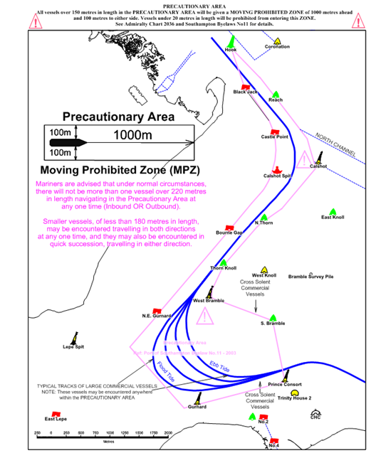
1. NOTICE IS HEREBY GIVEN in support of planning for the forthcoming busy season for all users of The Solent that all vessels navigating within the Port of Southampton shall ensure that a vessel greater than 220 metres in length overall shall be given a ‘clear channel’ in the area between the Hook Buoy and the Prince Consort Buoy (hereinafter referred to as ‘The Precautionary Area’ - (see Chartlet 1)).
The term ‘clear channel’ is defined as: ‘a clear and unimpeded passage ahead of a vessel when transiting the Precautionary Area’.
The term ‘clear channel vessel’ is defined as: ‘a vessel greater than 220 metres in length overall which requires a clear and unimpeded passage ahead when transiting the Precautionary Area’.
Vessels may enter ‘The Precautionary Area’ maintaining a safe distance astern of a ‘clear channel vessel’.
2. Two vessels each having a length greater than 180 metres length overall shall not pass or overtake each other between Hook Buoy and a line drawn due south of West Bramble Buoy.
3. Moving Prohibited Zone (MPZ) (See Chartlet 1)
Southampton Harbour Byelaws 2003 Byelaw No 11 enforces the requirement that all vessels over 150 metres in length overall when navigating within ‘The Precautionary Area’ referred to in this notice are automatically allocated a ‘Moving Prohibited Zone’ (MPZ). The MPZ is defined as an area extending 1000 metres ahead of the bow and 100 metres from the ship’s side on both sides of any vessel of over 150 metres in length overall whilst it is navigating within ‘The Precautionary Area’ (See Chartlet 1).
The master of a small vessel (defined in Southampton Harbour Byelaws 2003 Byelaw No 3 as any vessel of less than 20 metres in length or a sailing vessel) shall ensure that the vessel does not enter an MPZ.
For the purpose of indicating the presence of the MPZ the master of any vessel of over 150 metres length overall shall display on the vessel, where it can best be seen, by day, a black cylinder, and by night, 3 all round red lights in a vertical line.
4. Tracks followed by Large Vessels
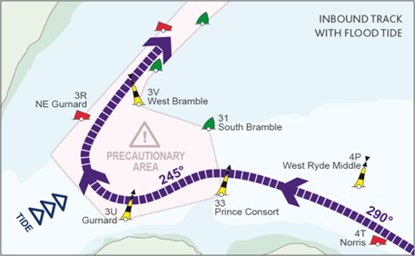
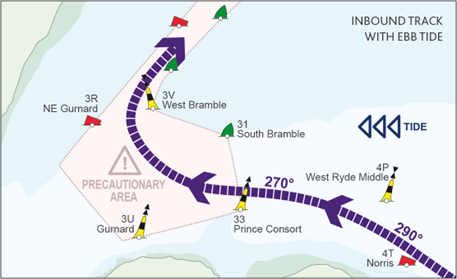
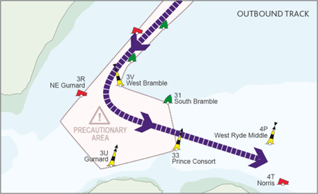
Masters of small vessels are advised that the tracks followed by large vessels within The Precautionary Area will vary considerably depending on the tidal and wind conditions prevailing at the time and the manoeuvring characteristics of the vessels themselves. Chartlets 2 to 4 below demonstrate likely tracks for both inbound and outbound vessels in flood and ebb tide conditions.
The tracks and courses shown are indicative only and inbound and outbound vessels may use the full extent of The Precautionary Area. Unless prevented by emergency circumstance, Masters of small vessels should give all large vessels in The Precautionary Area a wide berth and, in particular, they should ensure that they do not enter a vessel’s MPZ.
5. Inbound vessel tracks
Flood tide
If the tide is flooding, this will set an inbound ship to the east as it turns into the Thorn Channel. As it approaches The Precautionary Area, in vicinity of the Prince Consort Buoy, the ship will make a substantial alteration to port, of up to 40 degrees to the southwest towards Gurnard Buoy, in order to give the maximum turning area into the Thorn Channel. The turn to starboard may not be commenced until the ship is very close to or just passed Gurnard Buoy, thus allowing some set to the east in the approach to the Thorn Channel entrance (See Chartlet 2).
In flood tide conditions, Masters of small vessels are advised to closely monitor the bearing of a large vessel as it approaches The Precautionary Area and to allow for the alteration of course to port.
Ebb Tide
If the tide is ebbing, the ship will be set to the west in the turn and thus the turn to starboard into The Thorn Channel will commence much earlier and as much as 4 – 5 cables from Gurnard Buoy. In this case, the alteration to port at Prince Consort Buoy may be less obvious (See Chartlet 3).
6. Outbound vessel tracks
Flood and Ebb tide
All ships leaving Southampton via the Thorn Channel start their turn to port as soon as West Bramble Buoy has been cleared, in order that on steadying up, their final heading is north of Prince Consort Buoy and directly towards the main channel south of Ryde Middle Bank. However, in ebb tide conditions the ship will be set to the west during the turn and may use the full extent of the south eastern quadrant of The Precautionary Area (See Chartlet 4).
7. Southampton Harbour Master’s Patrol Launch
When operationally possible the Southampton Harbour Master’s Patrol Launch (VHF Call Sign ‘’SP’’ – watching VHF Channel 12) will precede all vessels over 150 metres in length overall within ‘The Precautionary Area’ showing, in addition to the normal steaming lights, an all round blue light. The absence of a patrol launch does not invalidate the implementation of a vessel’s MPZ.
Within The Precautionary Area all instructions given by the Southampton Harbour Master’s Patrol Launch should be acknowledged and promptly carried out.
Hythe Marina Village
Hythe Marina Village was the first marina village to be built in the UK and is still one of the finest. Located on Southampton Water’s western shore, it’s a unique development of a 206-berth marina, waterside homes, shops, restaurants, and a boutique hotel.
The marina entrance is controlled by lock gates, operated 24 hours a day throughout the year, and there is easy access to Southampton Water and several of our other marinas situated in and around the Solent. On nearing Hythe Knock red buoy, at the junction of the Rivers Itchen and Test, Hythe Marina Village is conspicuous to port just beyond Hythe Pier.
Call on VHF Ch. 80 or by mobile for clearance to lock-in and for a berth. Enter via a short channel aligned 220° and marked by beacons.
Hythe Marina has 206 berths; max LOA: 16m*; fuel (petrol/diesel); gas; boat lifting and storage ashore; 40-ton boat hoist; slipway; boat repairs; laundry facilities; bars and restaurants; boutique hotel; electric vehicle charging; pump out station, and MDL Wi-Fi.
Contact: Hythe Marina Village, Shamrock Way, Hythe, Southampton, SO45 6DY. Tel: 023 8020 7073. Website: hythemarinavillage.co.uk VHF Ch. 80.
*Larger vessels can be accommodated but check with marina in advance.
Ocean Village Marina
In the shelter of Southampton Water, and right in the heart of the city itself, Ocean Village Marina is much more than a marina. Surrounded by shops, restaurants, a cinema and bars, it offers outstanding recreational facilities. The basin, formerly used for commercial ships, is deep enough to offer mooring facilities for tall ships and large yachts. It has also become famous for hosting the start or finish of round-the-world yacht races. The marina is home to a £50m luxury spa hotel complex, the tallest residential building in the city, and exciting new restaurant and retail openings.
To approach Ocean Village Marina, at Weston Shelf green buoy - near the junction of the Rivers Itchen and Test, keep to starboard up the Itchen. Ocean Village is about 1 mile further north to port and just short of the Itchen Bridge.
Call on VHF Ch. 80 or by mobile for a vacant berth. Ocean Village has 326 berths, max LOA: 80m; laundry facilities; cinema, bars and restaurants; convenience stores; yacht brokerage; 5-star hotel and spa; dental clinic, beauty salon, electric vehicle charging; 24/7 self-storage facilities; and MDL Wi-Fi.
Contact: Ocean Village Marina, 1 Channel Way, Southampton, SO14 3QF. Tel: 023 8022 9385. VHF Ch. 80. Website: oceanvillagemarina.co.uk
Shamrock Quay
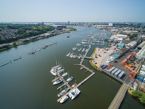
Credit Image: MDL Marinas Shamrock Quay
Shamrock Quay is a marina steeped in history, taking its name from the famous J-class yacht, Shamrock V when she had her first refit at the site in 1967. The 255-berth marina is still a major centre for refit and boat building with many specialist trades on site, as well as a bar and restaurant, café, and shops. With a 70-metre superyacht berth, a 60-metre visitor berth and a modern shower and toilet block, including disabled facilities, Shamrock Quay is able to cater for all boat owners.
To reach the marina, proceed up Southampton Water keeping clear of all commercial shipping. At Weston Shelf green buoy, near the junction of the Rivers Itchen and Test, keep to starboard up the Itchen and observe the 6-knot speed limit. Shamrock Quay is 1300m beyond the Itchen Bridge on the port side, opposite No 5 green beacon.
Shamrock Quay has 255 berths; max LOA: 70m; boat lifting and storage ashore; 75-ton travel hoist with a 3-ton jib crane; 25-ton boat mover; extensive marine trades and services; chandlery; laundry facilities; shops; bar and restaurant; café; yacht charters; electric vehicle charging; 24/7 self-storage facilities and MDL Wi-Fi.
Contact: Shamrock Quay, William Street, Northam, Southampton, SO14 5QL. Tel: 023 8022 9461. VHF Ch. 80. Website: shamrockquay.co.uk
Saxon Wharf
Credit Image: MDL Marinas Saxon Wharf
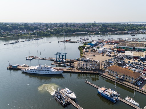
Saxon Wharf is a marine service centre offering outstanding facilities for superyachts and other large craft. Situated on Southampton’s River Itchen, north of Shamrock Quay, it’s the ideal location for big boats in need of secure, quick turnaround lift-outs, repair work or full-scale refits. Its position near the centre of Southampton gives it easy access to the motorway network. To reach Saxon Wharf, go past the Itchen Bridge and Shamrock Quay and follow the left bend past No. 9 green beacon. Saxon Wharf is to port, opposite Kemps Quay Marina.
Call on VHF Ch. 80 or by mobile for a vacant berth.
Saxon Wharf offers marina berths (max LOA: 80m) and 100 dry stack berths (max LOA: 13m); 200-ton boat hoist; storage ashore; fully serviced heavy-duty pontoons with electricity; extensive marine trades and services; fresh water; CCTV coverage; showers and toilets; car parking; 24/7 self-storage facilities; and MDL Wi-Fi.
Contact: Saxon Wharf, Lower York Street, Northam, Southampton, SO14 5QF. Tel: 023 8033 9490. Website: saxonwharf.co.uk VHF Ch. 80.
Kemp's Quay
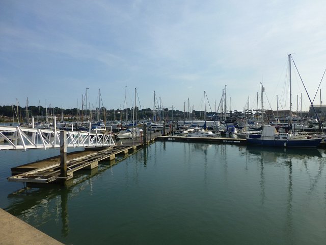
Image Credit: Kemps Quay
Kemp’s Quay has been established for over 100 years. The marina is situated on the east bank of the River Itchen, 2 miles north of the river mouth. Of the 260 berths available at the marina, 30 are non-tidal and afloat at all times, the remainder are semi-tidal. Hours afloat on these tidal berths vary in direct proportion to their proximity to the shore and are priced accordingly.
The river bed is soft mud and affords stable berths for most craft when the tide is away. A landing/loading berth, afloat at all times, is available for boat owners who cannot leave or land within the tide window. Kemp’s Quay has single point security access; lift out and storage ashore; travel hoist with an 8-ton capacity; power washing; hard standing - 6 weeks for up to 60 craft - included in the mooring fee; fresh water to all pontoons; toilets and shower block; owners’ store.
Contact: Kemps Shipyard Limited, Quayside Road, Southampton, SO18 1BZ. Tel: 02380 632323. Email: sarah@kempsquay.com Website: kempsquay.com
Town Quay Marina
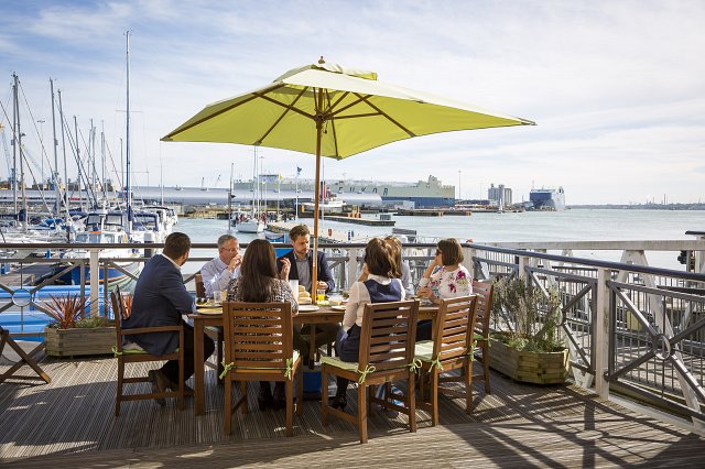
Image Credit: Completely Group- Town Quay
Town Quay Marina, located on the eastern shores of Southampton Water, has 130 berths and a dedicated visitors’ pontoon. In the heart of Southampton, the marina is within walking distance of the city’s shopping centre, restaurants, bars and theatres. The marina is well served by transport links to the Isle of Wight, the New Forest and London and lies next to the Southampton Boat Show. Entrance to the marina is via dogleg between two floating wave breaks that appear continuous from seaward. Beware of the adjacent Red Jet hi- speed ferry. The marina offers berthing assistance; contact them on VHF Ch 80 or by phone. The marina is part of the TransEurope Marinas group. It has a berth holders’ reception- with free drinks, and is an official Ocean Safety drop off/collection point and a SeaSafe service point for life jackets. There is a chillout deck with use of gas barbecue, free bicycle hire for all customers, a slipway, car parking, laundry room, top quality shower rooms, free WiFi and water on all berths.
Contact: Town Quay Marina, Associated British Ports, Management Office, Town Quay, Southampton, SO14 2AQ. Tel: 02380 234397 | 07764 293588 Email: info@townquay.com
Please note, this information is to be used as a guide only and not for navigation.
